Map in works to promote Milam tourism activities and hot spots
Rockdale Reporter, September 10, 2009, Page 6B
Plans are underway for the production of a Milam County Marketing and Tourism Map,
according to Joy Graham, chair of the committee responsible for the maps development
and distribution.
The map will by 18 by 24 inches and printed in full color on both sides. One side will
emphasize county features, listing historic sites and attractions and other information
important for visitors to the area. Highlighting the county side of the map will be the
National Historic Trail El Camino Real de los Tejas.
The other side will feature the communities of Milam County, listing annual events such
as the Rockdale Fair and the Buckholts Cotton Festival, listing dates and contact
numbers.
Communities participating in map production will have an opportunity to decide which
sites and which annual events they want to have listed on the map, Graham said.
This map will be distributed not only within Milam County but copies will also be
placed in the 11 visitor centers across the state.
Funding
Funding for the map to this date has been acquired from the Milam County Historical
Commission, with funds coming from the Commissions Preservation Trust Fund and from a
special grant awarded the Certified Local
Government Committee by the Texas Historical Commission.
Joining them in sponsoring the map are: Rockdale Chamber of Commerce, $2,000: City of
Thorndale, $1,000; Thorndale Chamber of Commerce, $100; Gause, $300; and the City of
Milano, $ 1,100. Contacts are being made with hotels, restaurants and business that
attract tourists.
Apache Pass features a documented river crossing dating back to the 17th century,
located adjacent to the mission sites listed in the National Register of Historic
Places. Also included is Rainbow Courts, oldest motel in continuous operation in the
Southwest.
A steering committee has been appointed for the purpose of planning sites and events to
be placed on the map, and includes: Carter Collins, Milano; Tense Tumlinson, Cameron;
Geri Burnett, Rockdale; Darlene Tucker,
Thorndale; Mary Ann Neely and Darlene Anglen, Gause; and Joy Graham, coordinator of the
project.
Anticipated release date for the map is January 2010.
Persons or organizations interested in having information listed on the map should
contact Graham immediately by calling 512-760-5924.
Milam County History
Prehistoric Indians
to
Twentieth Century
by
Joy Graham
Prehistoric Indians
to
Twentieth Century
by
Joy Graham
Milam County Historical Commission
Milam County, Texas
Milam County, Texas


MAPPING HISTORY
The new Milam County Historical Tourism Map is now being distributed to Texas 12 tourist
stations and venues in all 40 counties of the El Camino de los Tejas Historical Trail.
From left displaying the maps front and back are: Dee Dee Green, co-chair Milam County
Historical Commission; Joy Graham, project coordinator; Geri Burnett, co-chair, Milam
County Historical Commission; Delores Sonntag, Certified Local Government (CLG) chair.
The project cost $13,151 and was partially funded by a CLG grant. Major contributors
($1,000 or more) included the Historical Commission, Rockdale Chamber of Commerce, the
cities of Milano and Thorndale and the Rockdale Fair Association.
Rockdale Reporter, March 11, 2010
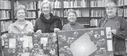
Photo credit: Mike Brown, Rockdale Reporter