Milam County Historical Commission
Milam County, Texas
Milam County, Texas


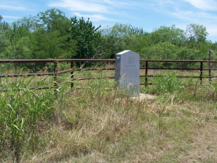
Port Sullivan
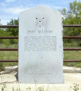
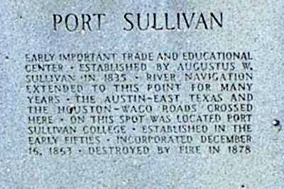
Port Sullivan
Early important trade and educational center -
established by Augustus W. Sullivan in 1835 - River
navigation exteded to this point for many years - The
Austin-East Texas and the Houston - Waco Roads crossed
here - On this spot was located Port Sullivan College -
Established in the early fifties - incorporated
December 16, 1853 - Destroyed by fire in 1878.
.
From Branchville/FM 485: east to CR 260;
1.1 miles north on CR 260
Taken from John Brockman's Master's Thesis
***
"PORT SULLIVAN, TEXAS
Port Sullivan was on a low bluff just downstream from a shoal of giant limestone boulders in the Brazos River, one mile northeast of Farm Road 485 in southeastern Milam County. A stone marker erected at the site in 1936, during the Texas Centennial,qv gave rise to the erroneous name Fort Sullivan. On December 12, 1835, August (or Augustus) W. Sullivan (Sillaven, Sillivan, Sullaven) gained title to the bluff overlooking the Brazos. In 1843 the steamboat Mustang traveled up the river as far as the bluff, demonstrating the possibility of steam navigation to this point. Steamboats again made it up the Brazos to this area in 1850. Reuben Anderson, a planter with land east of the river in Robertson County, persuaded Sullivan to subdivide his land on the bluff into town lots, and on May 1, 1851, two of Anderson's sons purchased the first lots sold in the new town. In 1852 Port Sullivan had a population of 200, four stores, one circular sawmill, two or three warehouses, and a post office. One merchant traveled to New York to purchase merchandise for his store. The town also had several doctors and a lawyer. Steamboats in Galveston advertised that through bills of lading would be issued on shipments up the Brazos to Port Sullivan. Shipments from the town included cotton, hides, and pecans. The fact that it was free from flooding, unlike the surrounding agricultural land, contributed greatly to the town's development. By 1860 the population of Port Sullivan had grown to 680, and Port Sullivan Male and Female College had been established.
During the summer of 1860 the Vigilance Committee of Port Sullivan lynched two men named Boatwright, an uncle and nephew, suspected of being abolitionists. In the presidential election of 1860, 224 votes were cast in the town, none of them for Abraham Lincoln or Stephen A. Douglas. On November 24, 1860, the Lone Star flag was raised in a ceremony supporting secession,qv and a delegate was sent to the Secession Convention.qv Port Sullivan voted on February 23, 1861, in favor of secession, 227 to 24. During Reconstructionqv Capt. George Haller, an officer in the United States Army, was killed near Port Sullivan in 1869. In the election for governor later that year, there was a disturbance involving Reuben A. Smith of Port Sullivan and Emil Adams when both tried to instruct some freedmen on how to vote in this crucial election. Because of this incident, the votes of Milam County were not counted, and the outcome of this very close election might have been altered.
Throughout the late 1860s and 1870s railway construction in the area lessened the importance of steamboat transportation, on which Port Sullivan was dependent. Citizens in the town met in 1869 to discuss plans for building a railroad, but they could not decide whether iron or wooden rails should be used. A railroad was chartered by the legislature, the Port Sullivan, Belton and Northwestern, to run from Hearne, the future junction of the International-Great Northern and the Houston and Texas Central railroads, to Port Sullivan and Belton. The road was never built. Later in 1869 the Houston and Texas Central reached Hearne and proceeded northward to start a new town called Calvert. Some who had purchased lots in Port Sullivan in 1851 and 1852 now bought lots in Calvert. The new town soon surpassed Port Sullivan in population and in trade.
Still there was hope that the International Pacific would cross the Brazos at Port Sullivan as it built westward from Hearne to Austin. But in 1873 this line chose a crossing a few miles downstream. Some remaining residents moved from Port Sullivan to the new town of Gause, five miles west of the Brazos. Port Sullivan's population probably reached a high point in the late 1860s, just before the railroad reached Calvert and just before the census was taken in 1870. In 1870 the population still stood at 1,423, but it declined to 123 by 1880, and the college closed by the end of the 1870s. By the 1890s the town had faded away.
In the early 1900s a cotton gin and general store were built near the old townsite, and a post office with the name of Port Sullivan was operating in 1914, but this community had no relation to the old steamboat port; the post office was discontinued by 1941. The old Port Sullivan cemetery, the only remaining landmark, is adjacent to a gravel road north of Farm Road 485, just west of the Brazos River. A series of abandoned concrete locks built by the United States Army Corps of Engineers between 1910 and 1920, long after the town had disappeared, remains in the river near the site of the old town.
BIBLIOGRAPHY: T. Lindsay Baker, Ghost Towns of Texas (Norman: University of Oklahoma Press, 1986). John Martin Brockman, Port Sullivan, Texas: Ghost Town (M.A. thesis, Texas A&M University, 1968).
John Martin Brockman"
.
Erected 1936